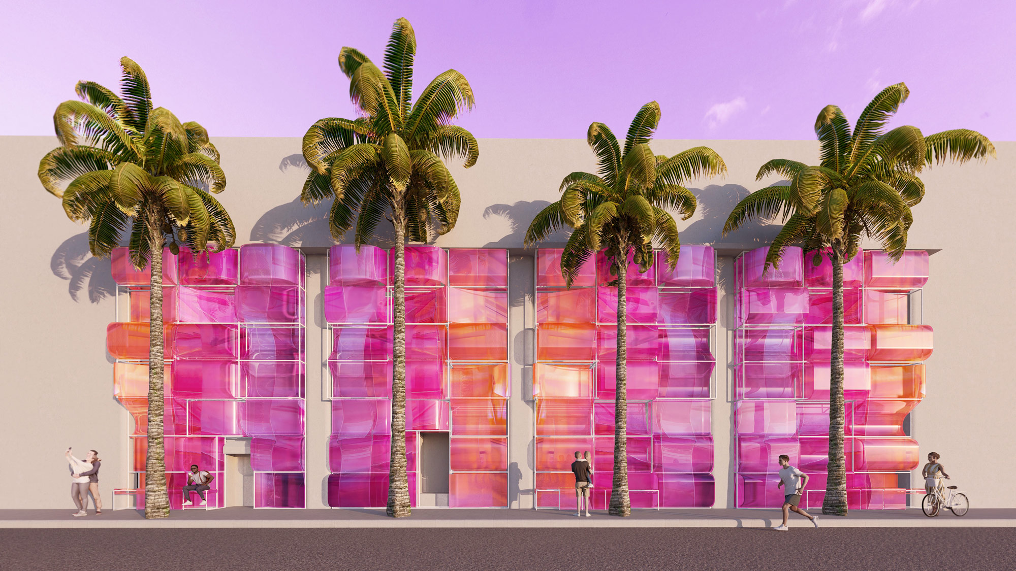
City

Axon and statistics on the potential for ININ infill housing infrastructure along the Park Avenue midtown Manhattan zoneAxon and statistics on the potential for ININ infill housing infrastructure along the Park Avenue midtown Manhattan zoneAxon and statistics on the potential for ININ infill housing infrastructure along the Park Avenue midtown Manhattan zoneAxon and statistics on the potential for ININ infill housing infrastructure along the Park Avenue midtown Manhattan zone
Perspective of a series of towers and landscaped connections above the desert floor of Phoenix by student Xingyu ZhongPerspective of a series of towers and landscaped connections above the desert floor of Phoenix by student Xingyu ZhongPerspective of a series of towers and landscaped connections above the desert floor of Phoenix by student Xingyu ZhongPerspective of a series of towers and landscaped connections above the desert floor of Phoenix by student Xingyu Zhong
Perspective of the exterior public spaces within a self-sustaining mountainside community by student Camille MedeirosPerspective of the exterior public spaces within a self-sustaining mountainside community by student Camille MedeirosPerspective of the exterior public spaces within a self-sustaining mountainside community by student Camille MedeirosPerspective of the exterior public spaces within a self-sustaining mountainside community by student Camille Medeiros
Elevation rendering of a modular system of housing based on an indoor/outdoor 'H' shaped unit by student Weicheng WangElevation rendering of a modular system of housing based on an indoor/outdoor 'H' shaped unit by student Weicheng WangElevation rendering of a modular system of housing based on an indoor/outdoor 'H' shaped unit by student Weicheng WangElevation rendering of a modular system of housing based on an indoor/outdoor 'H' shaped unit by student Weicheng Wang
Urban perspective drawing of a collection of branched housing towers that shade downtown Phoenix by student Yuchen ZhaoUrban perspective drawing of a collection of branched housing towers that shade downtown Phoenix by student Yuchen ZhaoUrban perspective drawing of a collection of branched housing towers that shade downtown Phoenix by student Yuchen ZhaoUrban perspective drawing of a collection of branched housing towers that shade downtown Phoenix by student Yuchen Zhao
Study of the various stacking programs that occur at the intersections of a new regional grid by student Salma Osuna LopezStudy of the various stacking programs that occur at the intersections of a new regional grid by student Salma Osuna LopezStudy of the various stacking programs that occur at the intersections of a new regional grid by student Salma Osuna LopezStudy of the various stacking programs that occur at the intersections of a new regional grid by student Salma Osuna Lopez
Top view of a physical model studying an infill region of towers and raised regional infrastructure by student Dellan RaishTop view of a physical model studying an infill region of towers and raised regional infrastructure by student Dellan RaishTop view of a physical model studying an infill region of towers and raised regional infrastructure by student Dellan RaishTop view of a physical model studying an infill region of towers and raised regional infrastructure by student Dellan Raish
Sequence of projected flood maps for Coney Island illustrating the inevitable natural transformation of the CISL siteSequence of projected flood maps for Coney Island illustrating the inevitable natural transformation of the CISL siteSequence of projected flood maps for Coney Island illustrating the inevitable natural transformation of the CISL siteSequence of projected flood maps for Coney Island illustrating the inevitable natural transformation of the CISL site
Photo of an accumulation of gray housing towers set within a park in Hong KongPhoto of an accumulation of gray housing towers set within a park in Hong KongPhoto of an accumulation of gray housing towers set within a park in Hong KongPhoto of an accumulation of gray housing towers set within a park in Hong Kong
Site plan diagramming public and private circulation around the alleyway infill site of the CART food cart housing projectSite plan diagramming public and private circulation around the alleyway infill site of the CART food cart housing projectSite plan diagramming public and private circulation around the alleyway infill site of the CART food cart housing projectSite plan diagramming public and private circulation around the alleyway infill site of the CART food cart housing project
Three monochrome towers set against a cloudy blue sky in Hong KongThree monochrome towers set against a cloudy blue sky in Hong KongThree monochrome towers set against a cloudy blue sky in Hong KongThree monochrome towers set against a cloudy blue sky in Hong Kong
Aerial perspective showing the ININ infill massing along Park Avenue on Manhattan as a reaction to housing needsAerial perspective showing the ININ infill massing along Park Avenue on Manhattan as a reaction to housing needsAerial perspective showing the ININ infill massing along Park Avenue on Manhattan as a reaction to housing needsAerial perspective showing the ININ infill massing along Park Avenue on Manhattan as a reaction to housing needs
Perspective collage illustrating the relationship between the ININ housing infill with adjacent park and public spacesPerspective collage illustrating the relationship between the ININ housing infill with adjacent park and public spacesPerspective collage illustrating the relationship between the ININ housing infill with adjacent park and public spacesPerspective collage illustrating the relationship between the ININ housing infill with adjacent park and public spaces
Urban site plan of the GBN Ministry of Parks merging with the functions of each urban force adjacent to the projectUrban site plan of the GBN Ministry of Parks merging with the functions of each urban force adjacent to the projectUrban site plan of the GBN Ministry of Parks merging with the functions of each urban force adjacent to the projectUrban site plan of the GBN Ministry of Parks merging with the functions of each urban force adjacent to the project
Elevated perspective of Park Avenue ININ infill housing through Harlem creating a vibrantly dense street and raised walkwayElevated perspective of Park Avenue ININ infill housing through Harlem creating a vibrantly dense street and raised walkwayElevated perspective of Park Avenue ININ infill housing through Harlem creating a vibrantly dense street and raised walkwayElevated perspective of Park Avenue ININ infill housing through Harlem creating a vibrantly dense street and raised walkway
Early massing study looking at the potential for a thickened wall-like mass creating micro-climates by student Marcia IbarraEarly massing study looking at the potential for a thickened wall-like mass creating micro-climates by student Marcia IbarraEarly massing study looking at the potential for a thickened wall-like mass creating micro-climates by student Marcia IbarraEarly massing study looking at the potential for a thickened wall-like mass creating micro-climates by student Marcia Ibarra
Concept drawing imagining the potential of a floating vertical city above the Phoenix fabric by student Brennan RichardsConcept drawing imagining the potential of a floating vertical city above the Phoenix fabric by student Brennan RichardsConcept drawing imagining the potential of a floating vertical city above the Phoenix fabric by student Brennan RichardsConcept drawing imagining the potential of a floating vertical city above the Phoenix fabric by student Brennan Richards
Exploded axon of the multiple connections and additions attached to the HEL linear bars throughout the airport intersectionExploded axon of the multiple connections and additions attached to the HEL linear bars throughout the airport intersectionExploded axon of the multiple connections and additions attached to the HEL linear bars throughout the airport intersectionExploded axon of the multiple connections and additions attached to the HEL linear bars throughout the airport intersection
Linear urban section illustrating the scale and massing of housing above the Phoenix lightrail by student Lexi SanchezLinear urban section illustrating the scale and massing of housing above the Phoenix lightrail by student Lexi SanchezLinear urban section illustrating the scale and massing of housing above the Phoenix lightrail by student Lexi SanchezLinear urban section illustrating the scale and massing of housing above the Phoenix lightrail by student Lexi Sanchez
Massing model illustrating a form of housing block that is lifted above the desert by student Monique PaulisMassing model illustrating a form of housing block that is lifted above the desert by student Monique PaulisMassing model illustrating a form of housing block that is lifted above the desert by student Monique PaulisMassing model illustrating a form of housing block that is lifted above the desert by student Monique Paulis
Flat axonometric drawing illustrating the duality of the split park and city infill approaching from the northFlat axonometric drawing illustrating the duality of the split park and city infill approaching from the northFlat axonometric drawing illustrating the duality of the split park and city infill approaching from the northFlat axonometric drawing illustrating the duality of the split park and city infill approaching from the north
Urban plan drawing of the circular forms contrasting the existing gridded fabric of Phoenix by student Brandon ShiehUrban plan drawing of the circular forms contrasting the existing gridded fabric of Phoenix by student Brandon ShiehUrban plan drawing of the circular forms contrasting the existing gridded fabric of Phoenix by student Brandon ShiehUrban plan drawing of the circular forms contrasting the existing gridded fabric of Phoenix by student Brandon Shieh
Layered animation showing the circulation and programs of the GBN within the massing shell created by the urban forcesLayered animation showing the circulation and programs of the GBN within the massing shell created by the urban forcesLayered animation showing the circulation and programs of the GBN within the massing shell created by the urban forcesLayered animation showing the circulation and programs of the GBN within the massing shell created by the urban forces
Urban plan illustrating a new lifted infrastructure above the highway interchange by student Genevieve MillerUrban plan illustrating a new lifted infrastructure above the highway interchange by student Genevieve MillerUrban plan illustrating a new lifted infrastructure above the highway interchange by student Genevieve MillerUrban plan illustrating a new lifted infrastructure above the highway interchange by student Genevieve Miller
Masterplan drawing showing the distinct neighborhoods around the airport site in relation to the HEL insertionMasterplan drawing showing the distinct neighborhoods around the airport site in relation to the HEL insertionMasterplan drawing showing the distinct neighborhoods around the airport site in relation to the HEL insertionMasterplan drawing showing the distinct neighborhoods around the airport site in relation to the HEL insertion
Section drawing of a modular city system that infills the horizontal and vertical spaces of Phoenix by student Andrew SynacekSection drawing of a modular city system that infills the horizontal and vertical spaces of Phoenix by student Andrew SynacekSection drawing of a modular city system that infills the horizontal and vertical spaces of Phoenix by student Andrew SynacekSection drawing of a modular city system that infills the horizontal and vertical spaces of Phoenix by student Andrew Synacek
Perspective of an atmospheric streetscape within a dense urban mass by student Monique PaulisPerspective of an atmospheric streetscape within a dense urban mass by student Monique PaulisPerspective of an atmospheric streetscape within a dense urban mass by student Monique PaulisPerspective of an atmospheric streetscape within a dense urban mass by student Monique Paulis
Diagram showing the infill site for the CART project within the skyline of New HavenDiagram showing the infill site for the CART project within the skyline of New HavenDiagram showing the infill site for the CART project within the skyline of New HavenDiagram showing the infill site for the CART project within the skyline of New Haven
Urban plan for an organic growth of housing and public facilities integrated into the mountains by student Camille MedeirosUrban plan for an organic growth of housing and public facilities integrated into the mountains by student Camille MedeirosUrban plan for an organic growth of housing and public facilities integrated into the mountains by student Camille MedeirosUrban plan for an organic growth of housing and public facilities integrated into the mountains by student Camille Medeiros
Temporal development of an organic infill city proposed by student Brayan Munoz illustrated through shifting elevationsTemporal development of an organic infill city proposed by student Brayan Munoz illustrated through shifting elevationsTemporal development of an organic infill city proposed by student Brayan Munoz illustrated through shifting elevationsTemporal development of an organic infill city proposed by student Brayan Munoz illustrated through shifting elevations
Exploded axon diagram of a concept proposal to develop housing about the highway interchange by student Genevieve MillerExploded axon diagram of a concept proposal to develop housing about the highway interchange by student Genevieve MillerExploded axon diagram of a concept proposal to develop housing about the highway interchange by student Genevieve MillerExploded axon diagram of a concept proposal to develop housing about the highway interchange by student Genevieve Miller
Animation of the phased plan for establishing the CISL infrastructure that will accept and allow for land transformationsAnimation of the phased plan for establishing the CISL infrastructure that will accept and allow for land transformationsAnimation of the phased plan for establishing the CISL infrastructure that will accept and allow for land transformationsAnimation of the phased plan for establishing the CISL infrastructure that will accept and allow for land transformations

RELATED PROJECTS

RELATED RESEARCH

RELATED NEWS