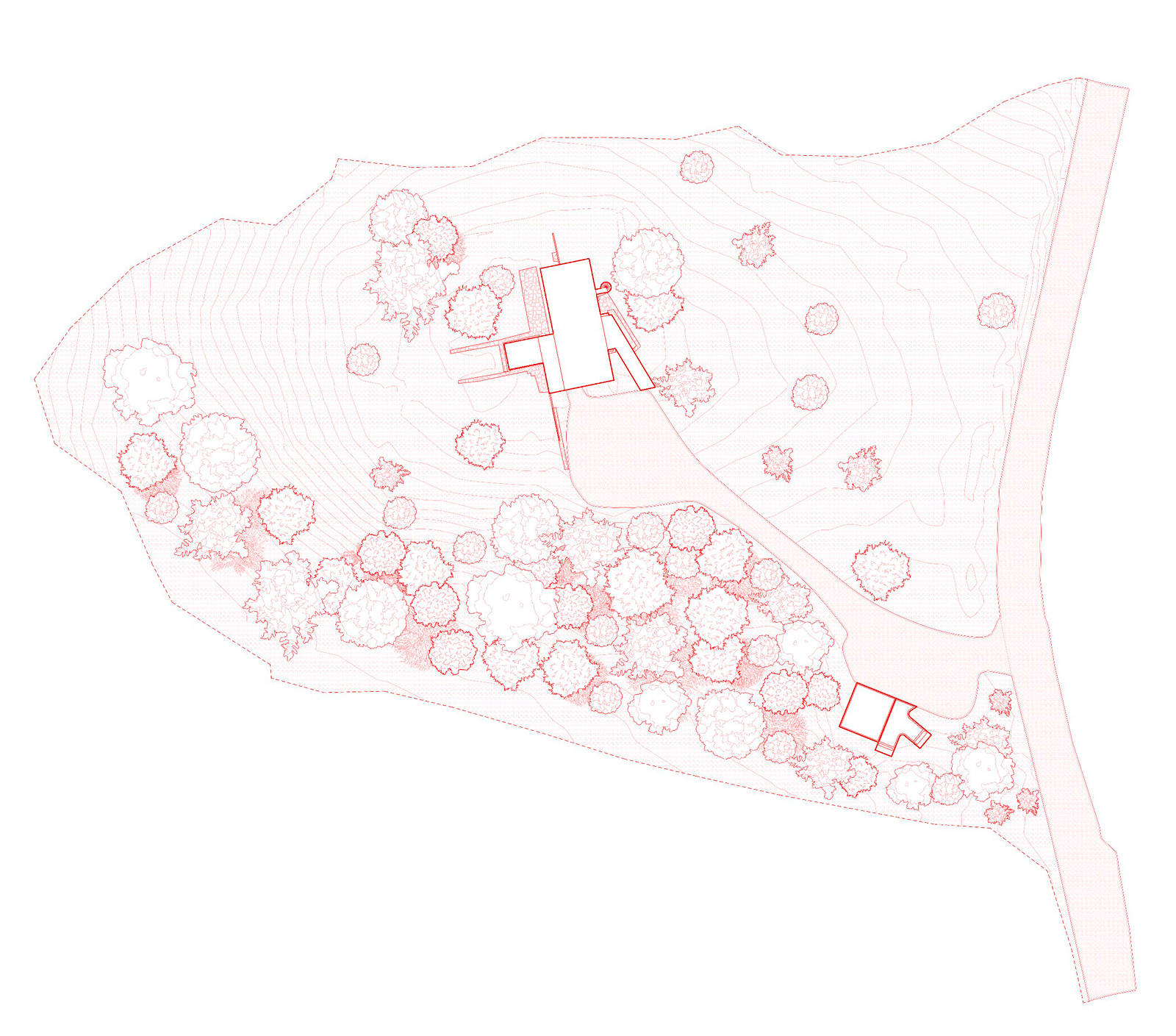
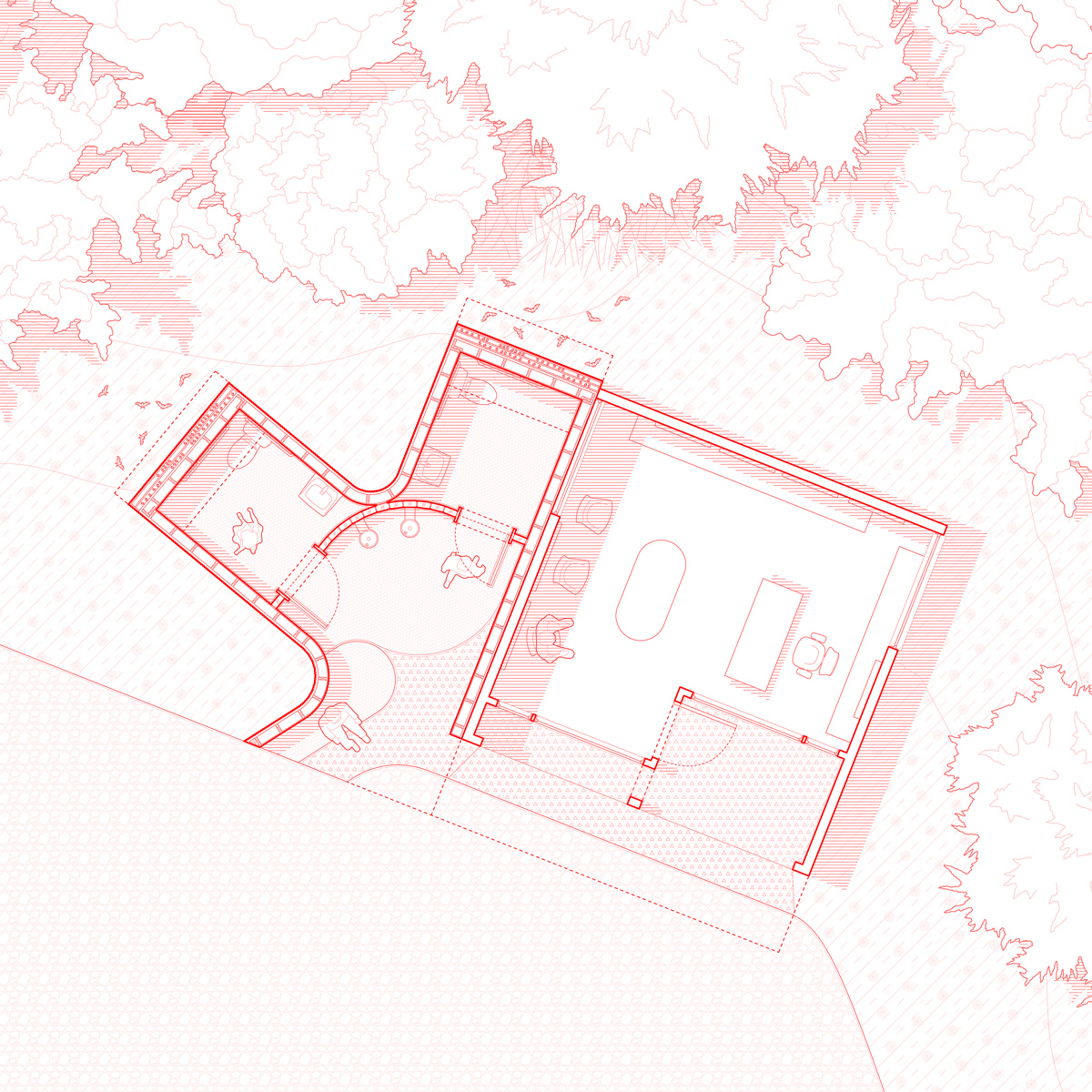
Plans

Series of sketch studies of the extended RACA gallery spaces spreading into the landscape from the central washSeries of sketch studies of the extended RACA gallery spaces spreading into the landscape from the central washSeries of sketch studies of the extended RACA gallery spaces spreading into the landscape from the central washSeries of sketch studies of the extended RACA gallery spaces spreading into the landscape from the central wash
Collection of 2D drawings of assorted sport topics from dimensions.comCollection of 2D drawings of assorted sport topics from dimensions.comCollection of 2D drawings of assorted sport topics from dimensions.comCollection of 2D drawings of assorted sport topics from dimensions.com
Urban plan emphasizing the creation of new shadows for walkable spaces throughout downtown Phoenix by student Marcia IbarraUrban plan emphasizing the creation of new shadows for walkable spaces throughout downtown Phoenix by student Marcia IbarraUrban plan emphasizing the creation of new shadows for walkable spaces throughout downtown Phoenix by student Marcia IbarraUrban plan emphasizing the creation of new shadows for walkable spaces throughout downtown Phoenix by student Marcia Ibarra
Aerial plan of the suburbs with the multiplication of additional backyard units by student Christopher FernandezAerial plan of the suburbs with the multiplication of additional backyard units by student Christopher FernandezAerial plan of the suburbs with the multiplication of additional backyard units by student Christopher FernandezAerial plan of the suburbs with the multiplication of additional backyard units by student Christopher Fernandez
Plan drawing illustrating multiple layers of a housing typology and shade canopy above Phoenix by student Yuchen ZhaoPlan drawing illustrating multiple layers of a housing typology and shade canopy above Phoenix by student Yuchen ZhaoPlan drawing illustrating multiple layers of a housing typology and shade canopy above Phoenix by student Yuchen ZhaoPlan drawing illustrating multiple layers of a housing typology and shade canopy above Phoenix by student Yuchen Zhao
Site plan for a new community of stepped housing units along the canal by student Isabelle BorieSite plan for a new community of stepped housing units along the canal by student Isabelle BorieSite plan for a new community of stepped housing units along the canal by student Isabelle BorieSite plan for a new community of stepped housing units along the canal by student Isabelle Borie
Plan and massing drawings showing the extent of the Phase 1 YELE build-out for bare minimal bathroom resources and spacePlan and massing drawings showing the extent of the Phase 1 YELE build-out for bare minimal bathroom resources and spacePlan and massing drawings showing the extent of the Phase 1 YELE build-out for bare minimal bathroom resources and spacePlan and massing drawings showing the extent of the Phase 1 YELE build-out for bare minimal bathroom resources and space
Urban site plan of the GBN Ministry of Parks merging with the functions of each urban force adjacent to the projectUrban site plan of the GBN Ministry of Parks merging with the functions of each urban force adjacent to the projectUrban site plan of the GBN Ministry of Parks merging with the functions of each urban force adjacent to the projectUrban site plan of the GBN Ministry of Parks merging with the functions of each urban force adjacent to the project
Urban plan combining various scattered housing forms across a reclaimed landscape by student Cecile KimUrban plan combining various scattered housing forms across a reclaimed landscape by student Cecile KimUrban plan combining various scattered housing forms across a reclaimed landscape by student Cecile KimUrban plan combining various scattered housing forms across a reclaimed landscape by student Cecile Kim
Plan view revealing the blurring of stepping housing forms into existing mountainous valleys by student Lamarra CarterPlan view revealing the blurring of stepping housing forms into existing mountainous valleys by student Lamarra CarterPlan view revealing the blurring of stepping housing forms into existing mountainous valleys by student Lamarra CarterPlan view revealing the blurring of stepping housing forms into existing mountainous valleys by student Lamarra Carter
Drawings of the Libreville avenue masterplan and the selected site for the GBN Ministry of Parks at the intersectionDrawings of the Libreville avenue masterplan and the selected site for the GBN Ministry of Parks at the intersectionDrawings of the Libreville avenue masterplan and the selected site for the GBN Ministry of Parks at the intersectionDrawings of the Libreville avenue masterplan and the selected site for the GBN Ministry of Parks at the intersection
Plan drawing of all of the Alternative Desert City proposals located in various sites across the city of Phoenix by studentsPlan drawing of all of the Alternative Desert City proposals located in various sites across the city of Phoenix by studentsPlan drawing of all of the Alternative Desert City proposals located in various sites across the city of Phoenix by studentsPlan drawing of all of the Alternative Desert City proposals located in various sites across the city of Phoenix by students
Combination of plan drawings of linear housing that steps over Camelback Mountain by student Lindsey GriffithCombination of plan drawings of linear housing that steps over Camelback Mountain by student Lindsey GriffithCombination of plan drawings of linear housing that steps over Camelback Mountain by student Lindsey GriffithCombination of plan drawings of linear housing that steps over Camelback Mountain by student Lindsey Griffith
Site plan diagramming public and private circulation around the alleyway infill site of the CART food cart housing projectSite plan diagramming public and private circulation around the alleyway infill site of the CART food cart housing projectSite plan diagramming public and private circulation around the alleyway infill site of the CART food cart housing projectSite plan diagramming public and private circulation around the alleyway infill site of the CART food cart housing project
Site plan for a first community and future expansion plans on the mountains above Saguaro Lake by student Camille MedeirosSite plan for a first community and future expansion plans on the mountains above Saguaro Lake by student Camille MedeirosSite plan for a first community and future expansion plans on the mountains above Saguaro Lake by student Camille MedeirosSite plan for a first community and future expansion plans on the mountains above Saguaro Lake by student Camille Medeiros
Plan of the existing Camelback mountain and proposal for contour-based housing ribbons by student Stephen AdrianPlan of the existing Camelback mountain and proposal for contour-based housing ribbons by student Stephen AdrianPlan of the existing Camelback mountain and proposal for contour-based housing ribbons by student Stephen AdrianPlan of the existing Camelback mountain and proposal for contour-based housing ribbons by student Stephen Adrian
Plan view of a mountainous model by student Stephen Adrian depicting ribboned layers of housing built into Camelback mountainPlan view of a mountainous model by student Stephen Adrian depicting ribboned layers of housing built into Camelback mountainPlan view of a mountainous model by student Stephen Adrian depicting ribboned layers of housing built into Camelback mountainPlan view of a mountainous model by student Stephen Adrian depicting ribboned layers of housing built into Camelback mountain
Animation of the various plans possible within the zoning setbacks for the ININ infill housing proposalAnimation of the various plans possible within the zoning setbacks for the ININ infill housing proposalAnimation of the various plans possible within the zoning setbacks for the ININ infill housing proposalAnimation of the various plans possible within the zoning setbacks for the ININ infill housing proposal
Physical model of a group of towers and connections in student Brayan Munoz's proposal for a dense vertical infill communityPhysical model of a group of towers and connections in student Brayan Munoz's proposal for a dense vertical infill communityPhysical model of a group of towers and connections in student Brayan Munoz's proposal for a dense vertical infill communityPhysical model of a group of towers and connections in student Brayan Munoz's proposal for a dense vertical infill community
Plan drawing of the swirling university paths wrapping the fragments of university buildings and housing around UIPlan drawing of the swirling university paths wrapping the fragments of university buildings and housing around UIPlan drawing of the swirling university paths wrapping the fragments of university buildings and housing around UIPlan drawing of the swirling university paths wrapping the fragments of university buildings and housing around UI
Plan and elevation drawings of an individual seat placed within the Meta-Bench frameworkPlan and elevation drawings of an individual seat placed within the Meta-Bench frameworkPlan and elevation drawings of an individual seat placed within the Meta-Bench frameworkPlan and elevation drawings of an individual seat placed within the Meta-Bench framework
Satellite aerial highlighting the various farming circles in Phoenix that could integrate housing by student Alejandra LobatoSatellite aerial highlighting the various farming circles in Phoenix that could integrate housing by student Alejandra LobatoSatellite aerial highlighting the various farming circles in Phoenix that could integrate housing by student Alejandra LobatoSatellite aerial highlighting the various farming circles in Phoenix that could integrate housing by student Alejandra Lobato
Combined drawing of all of the various UI tower floor plans and section showing the variety of discoverable study spacesCombined drawing of all of the various UI tower floor plans and section showing the variety of discoverable study spacesCombined drawing of all of the various UI tower floor plans and section showing the variety of discoverable study spacesCombined drawing of all of the various UI tower floor plans and section showing the variety of discoverable study spaces
Urban plan of downtown Phoenix showing the future housing infrastructure cloud above the city by student Brennan RichardsUrban plan of downtown Phoenix showing the future housing infrastructure cloud above the city by student Brennan RichardsUrban plan of downtown Phoenix showing the future housing infrastructure cloud above the city by student Brennan RichardsUrban plan of downtown Phoenix showing the future housing infrastructure cloud above the city by student Brennan Richards
Plan and axonometric drawing of visitors relaxing on towels on the urban beach below the UTO at MoMA PS1Plan and axonometric drawing of visitors relaxing on towels on the urban beach below the UTO at MoMA PS1Plan and axonometric drawing of visitors relaxing on towels on the urban beach below the UTO at MoMA PS1Plan and axonometric drawing of visitors relaxing on towels on the urban beach below the UTO at MoMA PS1
Overall building tower plan with three units, vertical circulation and plan on each floor with FVDC unit delivery systemOverall building tower plan with three units, vertical circulation and plan on each floor with FVDC unit delivery systemOverall building tower plan with three units, vertical circulation and plan on each floor with FVDC unit delivery systemOverall building tower plan with three units, vertical circulation and plan on each floor with FVDC unit delivery system
Sequence of projected flood maps for Coney Island illustrating the inevitable natural transformation of the CISL siteSequence of projected flood maps for Coney Island illustrating the inevitable natural transformation of the CISL siteSequence of projected flood maps for Coney Island illustrating the inevitable natural transformation of the CISL siteSequence of projected flood maps for Coney Island illustrating the inevitable natural transformation of the CISL site
Plan drawing animation showing the various occupiable spaces within the triangulated GBN Ministry of Parks footprintPlan drawing animation showing the various occupiable spaces within the triangulated GBN Ministry of Parks footprintPlan drawing animation showing the various occupiable spaces within the triangulated GBN Ministry of Parks footprintPlan drawing animation showing the various occupiable spaces within the triangulated GBN Ministry of Parks footprint
Plan and massing drawings of Phase 2 of YELE including the first studio, recording booth, and reception areaPlan and massing drawings of Phase 2 of YELE including the first studio, recording booth, and reception areaPlan and massing drawings of Phase 2 of YELE including the first studio, recording booth, and reception areaPlan and massing drawings of Phase 2 of YELE including the first studio, recording booth, and reception area
Urban plan illustrating the modular growth of a stacked city around a linear infrastructure of Tempe by student Weicheng WangUrban plan illustrating the modular growth of a stacked city around a linear infrastructure of Tempe by student Weicheng WangUrban plan illustrating the modular growth of a stacked city around a linear infrastructure of Tempe by student Weicheng WangUrban plan illustrating the modular growth of a stacked city around a linear infrastructure of Tempe by student Weicheng Wang
Exploded plan drawing showing the many layers of the proposed Hellinikon system of two linear bars and other programsExploded plan drawing showing the many layers of the proposed Hellinikon system of two linear bars and other programsExploded plan drawing showing the many layers of the proposed Hellinikon system of two linear bars and other programsExploded plan drawing showing the many layers of the proposed Hellinikon system of two linear bars and other programs
Introduction image of the Alternative Desert Cities studio showing a colorized map of the Phoenix sprawlIntroduction image of the Alternative Desert Cities studio showing a colorized map of the Phoenix sprawlIntroduction image of the Alternative Desert Cities studio showing a colorized map of the Phoenix sprawlIntroduction image of the Alternative Desert Cities studio showing a colorized map of the Phoenix sprawl